This is not nearly an exhaustive list, but here are some MORRIS deeds from Craven County, NC.
| GRANTEE | GRANTOR | BOOK- |
PAGE- |
YEAR- |
| Peter MORRIS | Charles MORRIS | 27 | 286 | 1791 |
| William MORRIS | Jesse HOWREN (HOWLAND) | 36 | 181 | 1802 |
| John MORRIS | William BROOKS | 36 | 573 | 1805 |
| James MORRIS | William GATLIN | 36 | 728 | 1805 |
| Laban MORRIS | Levi GATLIN Et Al | 39 | 589 | 1814 |
| Deborah MORRIS | George GODETTE, Sr. | 41 | 188 | 1818 |
| Susannah MORRIS | William JONES | 43 | 305 | 1823 |
| Susannah MORRIS | Sarah MORRIS Et Al | 43 | 307 | 1822 |
| Susannah MORRIS | Levi WEST | 46 | 301 | 1829 |
| Nancy MORRIS Et Al | William JONES | 46 | 444 | 1829 |
| Nancy MORRIS | William JONES | 49 | 319 | 1829 |
Susan MORRIS & Wm MCINTOSH |
James MCINTOSH | 49 | 164 | 1832 |
| John W. MORRIS | Joseph MORRIS (Shf) | 50 | 168 | 1833 |
| John & William MORRIS | Samuel STREET | 50 | 320 | 1832 |
| William MORRIS | William MCINTOSH | 54 | 169 | 1837 |
| William MORRIS | Henry ANDERSON | 59 | 479 | 1849 |
| Levi MORRIS | Allen ANDERSON | 60 | 144 | 1849 |
| William B. MORRIS | Southey WETHERINGTON | 65 | 440 | 1859 |
| William B. MORRIS | Samuel SMITH | 65 | 465 | 1853 |
| William B. MORRIS | William MORRIS | 65 | 472 | 1853 |
| William MORRIS | John MORRIS | 65 | 473 | 1850 |
| Levi P. MORRIS, Heirs of | Levi P. MORRIS | 69 | 219 | 1867 |
| ” “ | John A. WILLIAMS | 69 | 219 | 1867 |
| William Roland MORRIS | Chapman WILLIEFORD Et Al | 82 | 268 | 1880 |
| William Roland MORRIS | Johnson FILLINGAM Et Al | 86 | 131 | 1882 |
| William B. MORRIS | William H. MORRIS | 82 | 444 | 1880 (cancelled) |
| D.S. (Dorsey Samuel) MORRIS | Mary WIGGINS Et Al | 88 | 183 | 1883 |
| William B. MORRIS | Patrick NORRIS | 92 | 135 | 1883 |
| D.S. (Dorsey Samuel) MORRIS | D. D. SMITH Et Al | 138 | 260 | 1901 |
| William Roland MORRIS | Levi M. MORRIS | 149 | 450 | 1887 |
| GRANTS were recorded for the following: |
||||
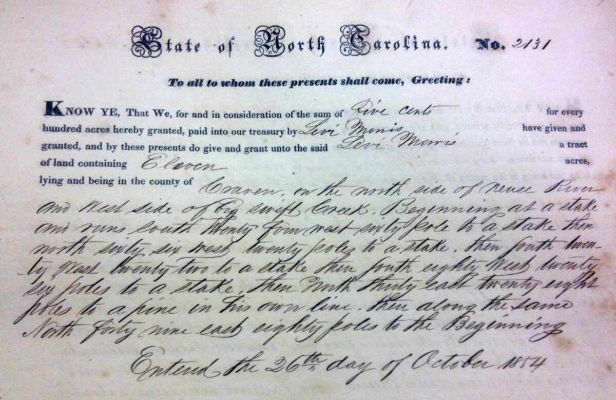
| Levi MORRIS, 1855, Grant Book 5, Page 171 | ||||
| William B. MORRIS, 1905, Grant Book 5, Page 294 | ||||
| William R. MORRIS, 1905, Grant Book 5, Page 294 | ||||
William BROOKS to John MORRIS – 9 March 1805 (36/573)
Eleven dollars, fifty acres on North side of the Neuse… between Francis BOND’s corner & William BROOKS’ corner. Signed by William BROOKS. Witnesses: Joshua CARRAWAY, John CARRUTHERS
William GATLIN to James MORRIS – 1805 (36/728)
Twenty pounds for a certain “of land lying and being in the County of Craven and on the north side of Neuse River and East side of little Swift Creek on the prong of Kitts Swamp, beginning at a pine in Saml SMITH and Runs So 10 W 40 poles… surveyed June 9th day 1797 containing 50 acres be the same more or less patented by John BURCH [illegible] and sold to Levi BURCH by John BURCH and sold to William GATLIN by Levi BURCH…” Signed by William GATLIN, March Term 1806. Witnesses: Abner GATLIN, Ephraim STILLEY
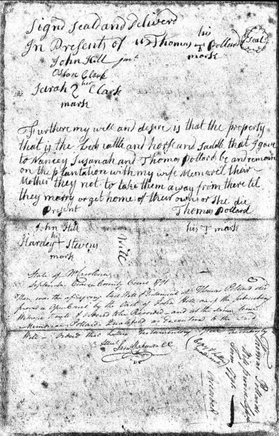
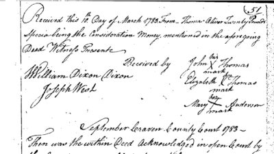
James MCINTOSH to Susan MORRIS and William MCINTOSH – 13 August 1832 (49/164)
“For and in consideration of the love and affection which I have for my son William MCINTOSH and my daughter Susan MORRIS wife of William MORRIS and for a further consideration of their finding & securing to me during my natural life a good & sufficient maintenance I do hereby give and grant… all my property which I own or am entitled to in any manner real & personal in the county of Craven reserving to myself the use of the plantation where I now live and any other article of personal property should I wish it during my life.” Signed by James MCINTOSH. Witness: Hardy WHITFORD
Samuel STREET to John and William MORRIS – 19 December 1832 (50/320)
“For and in consideration of the sum of eight hundred dollars… a tract of land patented by Thomas HASLIN in the year 1774 lying on the North side Neuse River and South side of Swift Creek and on both sides of the Bear Hold Swamp, Beginning at a pine John ANDERSON’s corner near Stockwell BRIGHT’s line running Norrth 46 Wt 156 poles to a pine his corner on MILLER’s island then with Charles JAMES’ line No. 60 Wt 180 poles to a pine his corner on the Oak ridge, then So 30 Wt 400 poles crossing Bear hold Swamp to a pine then down the swamp So 79 Et 256 poles to a stake and thence to the beginning, containing five hundred and twenty acres more or less, the said Samuel STREET not intending by these presence to convey to the said William & John MORRIS that part of the said tract of land pressed? to Jonas & Charles ANDERSON…” Signed by Samuel STREET. Witnesses: Amon JOYNER, Stephen WITHERINGTON
Henry ANDERSON to William MORRIS – 8 January 1849 (59/479)
“For and in consideration of the sum of One hundred and fifty Dollars… a certain tract or parcel of land in the County and State aforesaid (Craven), beginning at a pine usually called Charles ANDERSON’s corner at the ditch on Hog Savanna & Bay Bush then North to Southy WETHERINGTON’s line and with his line to Reuben ANDERSON’s line with Reuben ANDERSON’s line to a lightwood stake on the South side of Rueben ANDERSON’s Mill pond called the KEMP’s corner South fifty seven West 180 poles to a pine on MILLERs Island then with said Henry ANDERS line to his corner thence to the first station containing one hundred and fifty acres be the same more or less…” Signed by Henry ANDERSON. Witnesses: Joseph MORRIS, Labin MORRIS
Allen ANDERSON to Levi MORRIS – 12 March 1849 (60/144)
“… in consideration of the sum of Thirty five Dollars in hand paid by the said Levi MORRIS … a tract of land situated in the County of Craven on the North side of Neuse river, bounded as follows, beginning at a pine Jacob JONSONs beginning corner on the side of the Bay Bush by a warrant granted to Joseph JAMES No 357 issued the 12th day of March 1787 thence running South fifty East one hundred and two pole to a pine thence forty seven degrees East, one hundred pole thence South ten degrees East to the Bear hole swamp thence up the various courses the same to JONSONs line thence with the same to the first station containing fifty acres be the same more or less…” Signed by Allen ANDERSON. Witness: William [his X mark] CRUEMAN? illegible name
Southey WETHERINGTON to William B. MORRIS – 4 October 1859 (65/440)
“For and in consideration of the Sum of Two hundred dollars… a certain tract or parcel of land in the County and State aforesaid (Craven) & on the North Side of Neuse River and South side of Swift Creek adjoining his own lands and others and bounded as follows (Viz:) Beginning at a Black Jack the third corner of Garret JOHNSON’s patent for one hundred acres and thence South 35 East 127 poles with his line to his Corner then with his other line North 55 East 127 poles to his beginning corner on or near the Bay Bush branch then up the said Branch to the division line between Clarissa WETHERINGTON and said William B. MORRIS then with said line North 87 West to the beginning containing Fifty nine acres more or less…” Signed by Southey [his X mark] WETHERINGTON. Witnesses: G N WILLIS, Spier WETHERINGTON
William MORRIS to William B. MORRIS – 9 December 1853 (65/472)
“For and in consideration of the sum of twenty five dollars… a certain tract or parcel of Land in the County and State aforesaid (Craven) on the waters of Swift Creek adjoining the lands of said William MORRIS and William B MORRIS and others bounded as follows: Beginning at a pine in the Second line of the John ANDERSON patent running thence North twenty East Seventy one poles to the edge of said Swamp Sixty poles to the line of a patent granted to Charles JAMES for thirty acres thence with said line South twenty nine East thirty poles to a Lightwood Stake the second Corner of said John ANDERSON’s patent thence with the
second line of said patent South fifty five west one hundred and fifteen poles to the beginning containing twenty four acres more or less to have and to hold the said lane and premises…” Signed by William [his X mark] MORRIS. Witnesses: Levi M. MORRIS, Rolan MORRIS
John MORRIS to William MORRIS – 8 March 1850
Four hundred dollars… “a certain tract or parcel of land lying and being in the County aforesaid (Craven) on the North side of Neuse River and South side of Swift Creek being part of a patent granted to Thomas HASLIN bounded as follows Beginning at a Stake in a line of a forty one acre tract deeded to the said William MORRIS part of said Patent it being one of the dividing corners between the said William and John MORRIS and runs with the dividing line So 10 degrees West 200 pole to another of the dividing corners then along another of the dividing lines So 58 degrees East 174 pole & the given line of said patent then along the same No 44 degrees East 230 poles to the beginning of the same then along another line of the same No 46 degrees West 30 poles to a corner of a forty acre tract conveyed to Enoch ANDERSON part of the same Patent then along the lines of the same to the line of a forty acre tract of the said William MORRIS then along said line to the first section containing two hundred and eighty acres be the same more or less…” Signed by John [his X mark] MORRIS. Witnesses: Levi MORRIS, William B. MORRIS